The Role of ATAK in Improving Field Communication and Decision-Making
Real-Time Location Tracking for Field Teams
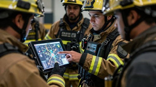
Imagine trying to coordinate a response when you don’t know where anyone is. That was the reality for many teams before tools like ATAK. This system lets everyone see where their colleagues are on a map, right as it happens. This real-time location tracking is a game-changer for field operations. It means no more guessing games or missed check-ins. Knowing exact positions helps managers direct resources effectively and keeps teams from getting lost or isolated.
This constant stream of location data builds a clear picture of the operational area. It’s not just about seeing dots on a map; it’s about understanding the spread of a situation and the proximity of response units. The ATAK platform makes this information accessible, helping to avoid confusion and improve overall safety for everyone involved.
Integrated Mapping and Data Visualization
ATAK doesn’t just show where people are; it brings all sorts of useful information together onto a single map. Think weather patterns, incident boundaries, or even the location of critical infrastructure. This integrated mapping makes it easier to grasp the whole picture at a glance. Instead of juggling multiple maps or reports, everything is consolidated in one place.
This visual approach helps teams understand complex situations quickly. They can see how different pieces of information relate to each other, which is vital when making fast decisions. The ability to overlay various data sets provides a much deeper understanding of the environment and the challenges at hand. This is where ATAK really shines in improving situational awareness.
Improved Coordination Across Disparate Units
When different agencies or teams need to work together, communication can get messy. ATAK helps bridge these gaps by providing a common operating picture. Everyone, from different departments or even different organizations, can see the same map and the same real-time updates. This shared view cuts down on misunderstandings and speeds up joint efforts.
This improved coordination is especially important in large-scale incidents where multiple units are involved. Whether it’s firefighters, law enforcement, or emergency medical services, ATAK allows them to see each other’s positions and intentions. This visibility helps prevent duplication of effort and ensures that resources are deployed where they are needed most. The ATAK system truly helps disparate units act as one cohesive team.
ATAK’s Impact on Emergency Response
Accelerating Response Times in Critical Incidents
When seconds count, ATAK makes a real difference. It cuts down the time it takes to get help where it’s needed most. Instead of fumbling with radios or trying to describe locations, everyone sees the same map. This means faster deployment of resources and quicker aid for those in trouble. The ability to see everyone’s location in real time is a game-changer for emergency services.
Think about a major accident. With ATAK, the first units on scene can immediately share their exact position and any immediate hazards. This information flows directly to dispatch and incoming units, allowing them to approach the scene safely and efficiently. This kind of coordination, made possible by ATAK, directly leads to shorter response times and better outcomes for victims.
ATAK helps teams get to the right place, at the right time, with the right information. It simplifies complex situations, allowing responders to focus on their job instead of figuring out where everyone is.
Facilitating Effective Wildfire Management
Wildfires are chaotic, and managing them requires constant updates. ATAK provides a common operating picture that fire managers can rely on. They can see the fire’s edge, track the movement of crews, and monitor the location of air support, all on one device. This makes coordinating efforts across vast, difficult terrain much simpler.
Information from aerial surveys, like fire perimeters and hot spots, can be pushed directly to ground crews through ATAK. This real-time data helps fire managers make smarter decisions about where to focus their efforts. It’s about giving them the best possible view of the situation so they can fight the fire more effectively and keep it from growing larger.
- Tracking crew locations for safety
- Visualizing fire spread in real-time
- Coordinating air and ground assets
Streamlining Search and Rescue Operations
In search and rescue missions, especially in remote areas, ATAK is proving to be incredibly useful. It helps teams pinpoint the location of a missing person or a stranded hiker much faster. When you’re out in the backcountry, every minute matters, and ATAK can mean the difference between a rescue before nightfall or a long, cold night in the wilderness.
Teams can share their search progress and findings directly on the map. This prevents duplication of effort and ensures that all areas are covered systematically. For command staff, seeing the status of all search teams at a glance allows for better resource allocation and quicker decision-making. The ATAK platform truly aids in getting people found and back to safety more efficiently.
| Operation Type | Typical Response Time (Pre-ATAK) | Estimated Response Time (With ATAK) |
| Backcountry Rescue | 4-8 hours | 1-3 hours |
| Urban Search | 15-30 minutes | 5-10 minutes |
Bridging Communication Gaps with ATAK
Interoperability Across Multiple Platforms
Before ATAK, getting different teams to talk to each other was a real headache. Imagine trying to coordinate a big event with people using all sorts of radios and phones. It was messy. ATAK changes that. It’s built to work with different systems, meaning a firefighter using an Android device with ATAK can share info with a search and rescue team using an iPhone with iTAK. This ability to connect across different devices and software is a big deal for field communication.
- ATAK connects Android devices.
- iTAK connects iOS devices.
- Both platforms share information on a common map.
This means everyone, no matter what phone they have, can see the same picture. It cuts down on confusion and makes sure everyone is on the same page, which is pretty important when you’re dealing with an emergency.
Seamless Data Sharing for All Responders
Think about a wildfire. You’ve got ground crews, helicopters, and command centers all needing to know what’s happening. ATAK makes it possible for all these different groups to share and see data in real time. A pilot flying over can drop a marker showing the fire’s edge, and that shows up instantly on the tablets of the firefighters below. This kind of real-time data sharing is what ATAK is all about.
The ability to push real-time map data out to the field makes a huge difference. It helps managers make faster, better decisions.
This constant flow of information means teams can react quicker. They can see where other units are, where the danger is, and where safe zones are. It’s like giving everyone a live, interactive map of the whole situation.
Consolidating Information for Command Staff
For those in charge, managing a large incident used to mean juggling calls, reports, and paper maps. ATAK pulls all that information into one place. Command staff can see the location of every team member, vehicle, and aircraft on a single screen. They can even see video feeds from drones or planes. This consolidated view helps them understand the big picture quickly.
- See all field units on one map.
- View incoming data from aircraft.
- Track progress and adjust plans easily.
This central hub of information is key to making smart decisions under pressure. ATAK helps command staff move from reacting to proactively managing the incident, making response efforts more effective.
The Evolution of ATAK Technology

From Military Origins to Civilian Applications
ATAK, or the Android Tactical Assault Kit, started life as a tool for military special operations. The goal was simple: give soldiers a way to see where their teammates were on a map in real-time. This wasn’t just about knowing who was where; it was about making sure everyone could work together better, especially when things got complicated. Think about it – in a chaotic situation, being able to see friendly forces and share immediate updates can make a huge difference.
As the technology proved its worth, people outside the military started to see its potential. Firefighters battling wildfires, search and rescue teams in remote areas, and law enforcement during large events realized that ATAK could help them too. The core idea of shared situational awareness and improved communication was universally applicable. This shift from a purely military tool to a broader public safety application marked a significant step in ATAK’s journey.
The ability to adapt ATAK for different needs has been key to its growth. It’s not just about tracking people; it’s about integrating various data streams, like weather information or aerial reconnaissance, onto a single, easy-to-understand map. This makes the original ATAK platform incredibly versatile for many different kinds of field operations.
ATAK’s Role in Decision-Making
Empowering Fire Managers with Actionable Data
ATAK gives fire managers a clear picture of what’s happening on the ground. They can see where their teams are, where the fire is moving, and where safety zones are located. This real-time information helps them make better choices, faster. The ability to push a real-time map of the fire out to the field through ATAK was pivotal in improving the decision-making of fire managers. This means they can react quickly to changing conditions.
- See team locations instantly.
- Track fire perimeters and spread.
- Identify safe zones and escape routes.
With ATAK, incident commanders no longer have to guess where everyone is. They have a common operating picture that everyone can see, leading to more informed decisions.
Enabling Dynamic Strategy Adjustments
Fires are unpredictable, and strategies need to change on the fly. ATAK makes this possible. If a new wind shift occurs or a spot fire pops up, managers can see it immediately on their ATAK map. They can then redirect resources, adjust containment lines, or change tactics without delay. This flexibility is key to controlling large incidents. The ATAK platform supports this by allowing for quick updates and data sharing.
Reducing Incident Scale Through Informed Choices
Ultimately, better decisions lead to smaller, more manageable incidents. By providing clear, up-to-the-minute data, ATAK helps responders get ahead of the fire. For example, on the Tamarack Fire, using ATAK allowed managers to adopt a more aggressive strategy, which reportedly kept the fire 16,000 acres smaller than it might have been. This shows how ATAK directly contributes to reducing the overall impact of an incident through smarter choices made in the field.
Looking Ahead
So, what does all this mean for folks working in the field? Basically, tools like TAK, especially with the new iOS version, are changing how teams work together. It’s not just for the military anymore; firefighters and rescue crews are finding it makes a real difference. Being able to see where everyone is and share information instantly cuts down on confusion and helps people make smarter choices, faster. This kind of tech can help get people out of danger quicker and make operations smoother. As more people start using it and give feedback, it’s likely to get even better, helping more first responders stay safe and do their jobs more effectively.